Moped Trip website

Dempster Highway

Page 8 of 8
Previous    Next


Mile 378.
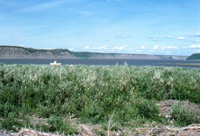
The confluence of the Arctic Red River and the MacKenzie River.

Visible in the distance are the ramparts along the MacKenzie River.

The MacKenzie River is the second largest River in North America in terms of volume of flow (the Mississippi is the largest), and the 3rd largest in the Western Hemisphere (the Amazon is the largest).


Another view of the MacKenzie River, near the same place.  The ferry is in the center distance.

This ferry boat serves three shores: North shore of the McKenzie River, the south shore of the MacKenzie River, and the town of Arctic Red River.

In 1978 this ferry only ran from noon to 8pm each day, and not on Tuesdays or Wednesdays! So if you missed it on Monday, you would've been stuck for two whole days!  Since I came north towards Arctic Red River on a Tuesday, I was stuck till Thursday waiting for the ferry!
I spent the day washing clothes, doing maintenance on the moped, and having a picnic with some folks from Fort MacPherson who came out to visit the place where I was camped.


A long straight stretch of road (18 miles!), through the taiga on the way north to Inuvik.

I found the people to be very friendly in Ft. MacPherson and Inuvik.  I had several invitations to stay in people's homes.


Mile 457: The outskirts of Inuvik.

I made it!!


A closeup of the moped, at Inuvik.

I carried two 1-gallon gas cans, a spare tire and inner tube, tent on the front, sleeping bag on the back along with my pack.  Food and tools and other items were carried in the saddle bags.


Previous    Next

On to the next section: Stewart-Cassiar Highway


The material on this page is copyright © by the original author/artist/photographer. This website is created, maintained & copyright © by Walter Muma
Please respect this copyright and ask permission before using or saving any of the content of this page for any purpose

Thank you for visiting!