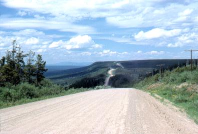
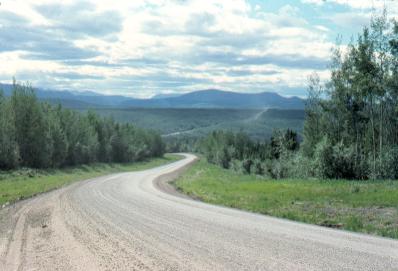
Moped Trip website

Alaska Highway

Page 2 of 15
Previous    Next


Mile 186

Trutch Mountain.

The Hwy ascends to an elevation of 4134 feet on Trutch Mtn.

For some reason, the Hwy was routed over the top of this mountain rather than through the valley of the Minaker River 1100 feet below (to the left in this photo). Makes for a nice view at least.


Between Mile 220 and 345 the Hwy passes through rather uninteresting country, scenery-wise. What I mean, is that there are no spectacular up-thrust mountains scratching the sky.
  

Mile 335

Kledo Creek campground.

This gives a good view of what the moped looks like all loaded up with my gear.

Also a typical campground along the Alaska Hwy.


Mile 352

Ascending Steamboat Mountain.

The Hwy ascends about 2000 feet along here.

That's the Muskwa River below in the distance.


Mile 362

Indian Head Mountain. It supposedly resembles the profile of an Indian.


Mile 363

This stretch is typical of the Alaska Hwy through this area.

Lots of dust from passing vehicles.  Fortunately, there wasn't all that much traffic.

I did have to be on guard from stones thrown up from passing vehicles, especially trucks. When a truck passed or a smaller vehicle traveling fast, I usually held my arm up to cover my face (I preferred to ride without a face plate on my helmet).

As well, the gravel surface required my constant attention lest I stray onto a softer graveled section and take a spill.


Mile 380

Tetsa River.

The Hwy travels alongside this river for about 30 miles, as it penetrates into the northern Rocky Mountains.

The northern Rockies are relatively wild and unspoiled, although oil and gas exploration was making inroads into them.


Previous    Next


The material on this page is copyright © by the original author/artist/photographer. This website is created, maintained & copyright © by Walter Muma
Please respect this copyright and ask permission before using or saving any of the content of this page for any purpose

Thank you for visiting!